


DescriptionKIT TRAIL 2 PLUS
This is a GPS with very complete mapping, choose from more than 30000 high resolution maps, there is even a TomTom road map. The TWONAV KIT TRAIL 2 PLUS BLUE is designed to be used in harsh conditions, large screen resistant Gorilla Glass, buttons can be handled with gloves and in the rain, IP67 standard. With its 20h battery life and robust design it is the ideal tool for professionals.
It is equipped with all the modern connectivity accessories, the Bluetooth allows it to synchronize with the Link application in order to receive WhatsApp notifications, it will also allow you to transfer the current routes on your phone, ideal in the field. With this GPS get 6 months of free SeeMe subscription that allows you to share your location live and send alert notifications to your contacts even without network, a great asset for your safety.
It's fully customizable and you can personalize it for each of your activities. Very versatile it will even attach to the handlebars of your bike or motorcycle with the support provided. Its screen is bright enough to remain readable in bright sunlight, this practical and durable GPS will follow you everywhere in your missions and adventures to ensure your safety and your orientation with precision.
DetailsKIT TRAIL 2 PLUS
- Big notch
- Dimensions: 80 x 131 x 20* mm *24 mm with QuickLock
- Weight : 220 gr
- Buttons: 4 on the front + 2 on the back
- Water/dust/mud resistance: IP67 standard
- MIL-STD-810 certification for temperature, shock, water and vibration resistance
- Extreme temperature resistance: -20 C ~ 50 C
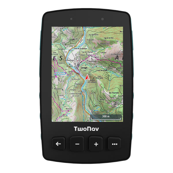
- Display: Touchscreen, Blanview with Optical Bonding and auto backlighting, 3.7", 480 x 640 pixels
- Internal Memory : 32 GB (free : 28 GB)
- No memory card support
- Light sensor
- Battery: Integrated 4000mAh, autonomy 20h
- MicroUSB port
- GPRS
- Barometer
- Digital compass
- Acclrometer
- Speaker
- Profiles customizable by sport disciplines
- Features: Superposition of several maps. Display of 3D maps. Unlimited creation of waypoints, routes and tracks. Download tracks and routes from online suppliers. Road navigation calculation. Estimation of the hardness of the destination. Entries on a certain duration, distance, heart rate and pace. Entries with Trackattack. Estimation of the calories spent. Configurable alerts. Automatic and manual laps. Altitude graph in real time. Over 120 data fields in real time. Customization of data pages. Customization of the device buttons. Live broadcasting with SeeMe. Emergency messages with SeeMe. Gocaching compatibility. Compatibility with e-Roadbooks. Automatic synchronization with Cloud GO
- Work with quality maps: Know the terrain you will be facing from the same GPS. With TwoNav you can load maps from the major map editors and move to them. Get more details on paths and shortcuts
- Navigation tools: Choose the type of navigation that best suits the type of activity you are going to do: free navigation, follow a track, go to precise coordinates, compass navigation... or just let yourself be guided by a roadbook
- Create waypoints on your route: Add information to your route by creating your own waypoints on the GPS screen. Click on the exact place where you want to create a point and add a name, an icon and a description (refuge, lake, fountain...)
- Configurable alerts: Reach the safety you are looking for during your outings, if you deviate from the planned route, the GPS will warn you so you can redirect your activity. In addition, if you exceed the speed limit, heart rate... you will also receive a warning
- Abundant and reliable data: It captures more than 120 data in real time (height, distance, elevation, power, speed...). Also, if you have a heart rate monitor or a cadence monitor, connect it and you will receive more information
- Estimated time of arrival: Let yourself be guided to your goal, at any time you know the distance and time remaining. When you return, the GPS will calculate the shortest route back home or to the starting point.
- LINK: Link the GPS to the Link application on your cell phone and you will receive notifications, calls and WhatsApp alerts on the GPS screen. In addition, if you have tracks on your smartphone, with Link you can automatically transfer them to the GPS
- SEEME: In unknown situations or in lack of coverage, asking for help is essential. With SeeMe you can broadcast your activity live wherever you are, plus you can also send emergency notifications to your contacts
- GO: Activate Cloud GO Sync and your trips will be automatically saved in your virtual space, a safe and secure place. Wherever you are, access your activity history from your GPS, smartphone or internet
- Included: Maps of your country. SIM card (integrated in the GPS). QuickLock stem/bike handlebar support (2 levels). USB-MicroUSB cable. 1 year free TwoNav PRO plan subscription. TwoNav App (Android/iOS). App Link (Android/iOS). Personal space on the GO Cloud. 6 months of SeeMe free
- Condition
- New
- Warranty
- 2 years
- Type
Mixed - Year
- 2023
ReviewKIT TRAIL 2 PLUS